Climate change, coastal engineering and risk management
Since 2008 extensive consultative projects have been undertaken in response to concerns about erosion of beaches and flooding events in coastal areas. This work has been overseen by an Integrated Assessment Project Manager within Council and was supported by a steering committee with representatives of the Council and from Commonwealth and State Government agencies.
An over-arching integrated assessment of climate change risks on coastal areas was completed in 2009 and included:
- consultation with community groups, institutions, state government agencies re their awareness and response to climate change issues
- assessment of localities and infrastructure which may be vulnerable to coastal hazards, both at present and into the future under anticipated sea-level rise
- investigation of adaptive management options in response to present and future coastal hazards
- preparation and execution of a communication plan to inform the community of the findings, initiate discussion about proposed responses and obtain feedback
Reports arising include:
- Climate Change Impacts on Clarence Coastal Areas – December 2008
- Winter 2011 Storm Events WRL Report
Climate change coastal impacts and adaptation consultations and planning
Community and partner consultations have been extensive and strategic review and update of Coastal Policy and Planning is ongoing.
- Clive Attwater (SGS Economics and Planning) – Project Outline and Policy and Planning Proposals
- Tasmanian Coastal Adaptation Pathways Project – Lauderdale Recommended Actions – May 2012
- Lauderdale environmental assets: assessment of climate change impact on coastal and marine areas – May 2012
- Coastal Hazards – Adaptations – Part 1
- Lauderdale and Roches Beach land ownership map
Monitoring of changes to Clarence coastal areas
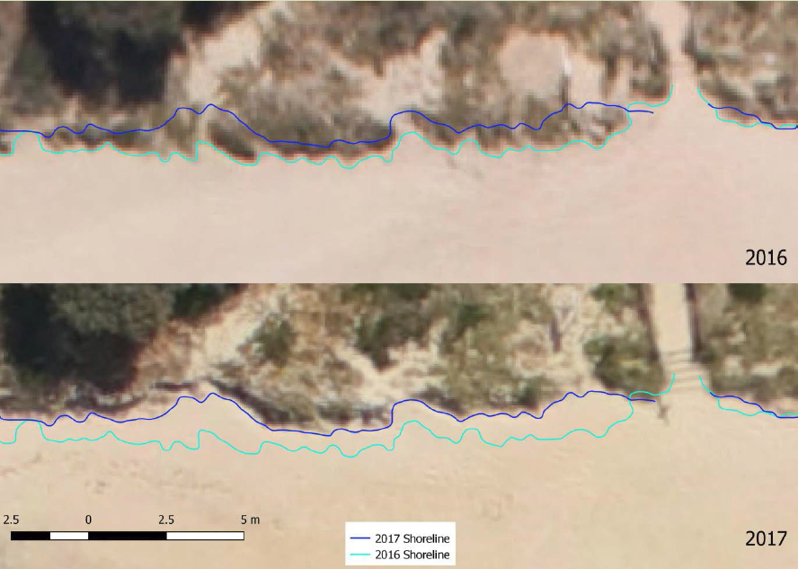
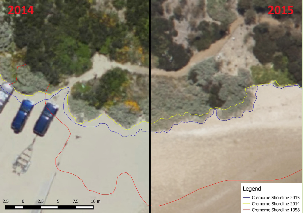
Beach erosion and coastal changes are monitored closely by council officers, through local citizen science contributions (the Tasmanian Shoreline and Monitoring Project TASMARC) and by extensive annual aerial photogrammetric monitoring of Clarence shorelines.
Beach monitoring reports:
- Beach sand profile at Roches Beach – Report
- North of Bambra Reef at Roches Beach – beach sand profile
- Seastar Bambra Report
- Roches and Cremorne Beaches – habitat mapping bathymetry and sediment analysis – dune nourishment
- Matt Dell – Clarence Shoreline Monitoring Report 2018-19
- Powerpoint Summary – Photogrammetry 1948 -2020 and Aerial monitoring 2011-2020 – 3 Dec 2020
- Clarence Shoreline Monitoring Program Report 2021-2022
The results from the 2016-17 survey show an easing of the rate of shoreline retreat at the majority of study sites.
The 2014-15 photos reveal the continued establishment of incipient dunes and associated vegetation along many of the beaches continuing a partial stabilisation of the shorelines since the 2011 erosion event.
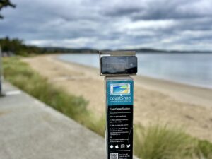
CoastSnap
Clarence residents can turn their everyday photos into valuable coastal data with a CoastSnap location at Bellerive Beach. CoastSnap is a global citizen science project that captures our changing coastlines. It relies on repeat photos submitted by citizens of the same location and helps track how the coast is changing over time.
At each monitoring point, such as at the western end of Bellerive Beach, a fixed position pole and camera cradle, is set up so that the Clarence community can capture images of the Bellerive Beach and share via social media or email.
These images are records which then provide real time data that help scientists better understand our beaches and forecast coastline changes in the coming decades.
Vire more about the project on the CoastSnap website: www.coastsnap.com